
Fix:La Réunion department relief location map.jpg
Grandia de esta previde: 645 × 600 pixeles Otra densias: 258 × 240 pixeles | 516 × 480 pixeles | 826 × 768 pixeles | 1,037 × 964 pixeles.
Fix orijinal (1,037 × 964 pixeles, grandia de fix: 244 KB, tipo MIME: image/jpeg)
Resoma
| Camera location | | View this and other nearby images on: OpenStreetMap |
|---|
| Descrive |
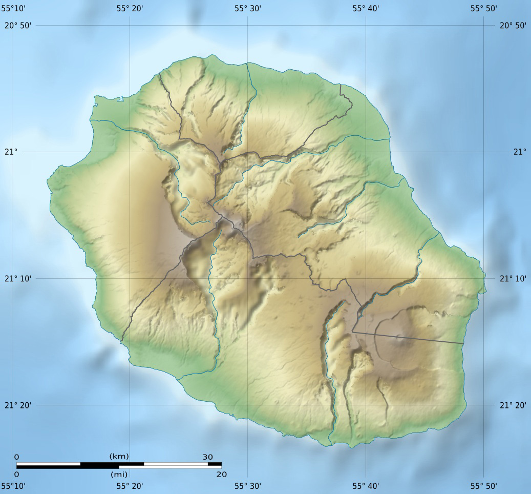
English: Blank physical map of the region and department of Réunion, France, for geo-location purpose.
Français : Carte physique vierge de la région et département de La Réunion, France, destinée à la géolocalisation. Scales: 1:372,000 (precision: 93 m) for the topography; 1:3,760,000 (precision: 940 m) for the bathymetry
Geographic limits of the map:
|
||
| Data | |||
| Fonte |
Obra propre
|
||
| Autor | Eric Gaba (Sting - fr:Sting) | ||
| Permete (Reusante esta fix) |
|
||
| Other versions |
Derivative works of this file: Circus maillardi distribution 1973-1975.png
|

Lisensa
I, the copyright holder of this work, hereby publish it under the following licenses:
Esta fix es lisensada su la lisensa Attribution-Share Alike 3.0 Unported de Creative Commons.
- Tu es libre:
- per comparti – per copia, distribui e transmete la obra
- per remisca – per ajusta la obra
- Su la constrinjes seguente:
- atribui – Tu debe atribui la obra en la modo spesifada par la autor o lisensor (ma no en cualce modo cual sujesta ce el aproba tu o tua usa de la obra).
- share alike – Si tu altera, muta o developa plu esta obra, tu pote distribui la obra resultante sola su la mesma lisensa o un simil a esta.

|
Permete es donada per copia, distribui e/o altera esta documento su la restrinjes de la GNU Free Documentation License, Varia 1.2 o cualce varia plu tarda publicida par la Free Software Foundation, sin partes nonvariante, sin testo de covrente fronte e sin testo de covrente retro. Un copia de la lisensa es incluida en la parte nomida GNU Free Documentation License. |
Tu pote eleje la lisensa cual tu prefere
Istoria de fix
Clica un data/ora per vide la fix en sua forma de alora.
| Data/Ora | Imajeta | Mesuras | Usor | Comenta | |
|---|---|---|---|---|---|
| aora | 14:00, 18 julio 2010 | | 1,037 × 964 (244 KB) | Sting | Color profile |
| 15:06, 23 marto 2009 |  | 1,037 × 964 (218 KB) | Sting | == Summary == {{Location|21|07|30|S|55|31|30|E|scale:500000}} <br/> {{Information |Description={{en|Blank physical map of the department of Réunion, France, for geo-location purpose.}} {{fr|Ca |
Usas de fix
La paje seguente lia a esta fix:
Usa global de fix
La otra vicis seguente usa esta fix:
- Usa en als.wikipedia.org
- Usa en am.wikipedia.org
- Usa en ar.wikipedia.org
- Usa en ast.wikipedia.org
- Usa en az.wikipedia.org
- Usa en be.wikipedia.org
- Usa en bg.wikipedia.org
- Usa en bs.wikipedia.org
- Usa en ceb.wikipedia.org
- Usa en ce.wikipedia.org
- Usa en ckb.wikipedia.org
- Usa en cs.wikipedia.org
- Usa en da.wikipedia.org
- Usa en de.wikipedia.org
- Usa en de.wikivoyage.org
- Saint-Denis (Réunion)
- Cilaos
- Saint-Pierre (Réunion)
- Saint-Leu (Réunion)
- Flughafen Réunion Roland Garros
- Le Port (Réunion)
- Le Tampon
- Saint-Paul (Réunion)
- Piton de la Fournaise
- Saint-Gilles-Les-Bains
- Diskussion:Piton de la Fournaise
- Modul:Location map data re
- Modul:Location map data re/Doku
- Saint-Philippe (Réunion)
- Usa en dsb.wikipedia.org
- Usa en el.wikipedia.org
Mostra plu usas global de esta fix.