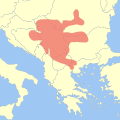
Fix:Vinča culture locator map.svg

Page contents not supported in other languages.
De Vicipedia

Fix orijinal(fix svg, densia: 1,000 × 1,000 pixeles, grandia: 517 KB)

Esta fix veni de Wikimedia Commons e es cisa usada par otra projetas. La descrive en sua paje de descrive de fix ala es mostrada a su.

Descrive Map of the Vinča culture according to Chapman, John (1981) The Vinča culture of south-east Europe: Studies in chronology, economy and society (2 vols), BAR International Series, 117, Oxford: B.A.R, p. 189 ISBN: 0-86054-139-8.
Data (UTC)
Fonte

Obra propre

This file was derived from: Blank Map of Europe -w boundaries.svg
Autor Joe Roe
I, the copyright holder of this work, hereby publish it under the following licenses:
w:en:Creative Commons
atribui share alike
Esta fix es lisensada su la lisensa Attribution-Share Alike 3.0 Unported de Creative Commons.
Tu es libre:
  • per comparti – per copia, distribui e transmete la obra
  • per remisca – per ajusta la obra
Su la constrinjes seguente:
  • atribui – Tu debe atribui la obra en la modo spesifada par la autor o lisensor (ma no en cualce modo cual sujesta ce el aproba tu o tua usa de la obra).
  • share alike – Si tu altera, muta o developa plu esta obra, tu pote distribui la obra resultante sola su la mesma lisensa o un simil a esta.
This licensing tag was added to this file as part of the GFDL licensing update.
GNU head Permete es donada per copia, distribui e/o altera esta documento su la restrinjes de la GNU Free Documentation License, Varia 1.2 o cualce varia plu tarda publicida par la Free Software Foundation, sin partes nonvariante, sin testo de covrente fronte e sin testo de covrente retro. Un copia de la lisensa es incluida en la parte nomida GNU Free Documentation License.
Tu pote eleje la lisensa cual tu prefere

Original upload log

This image is a derivative work of the following images:

  • File:Blank_Map_of_Europe_-w_boundaries.svg licensed with Cc-by-sa-3.0-migrated, GFDL
    • 2008-06-19T01:33:53Z Roke 2045x1720 (724499 Bytes) more accurate version derived from [[:Image:Location European nation states.svg]] using same colours
    • 2006-09-25T23:00:04Z Madman2001 748x546 (224972 Bytes) A blank map of Europe using Wikipedia standard colors in SVG format, based on [[:Image:BlankMap-Europe-v5.png]]. Note that the borders represent a second object "grouped" with the outline of Europe.

Uploaded with derivativeFX

Captions

Add a one-line explanation of what this file represents

Items portrayed in this file

depicts English

copyrighted English

inception English

16 setembre 2010

Istoria de fix

Clica un data/ora per vide la fix en sua forma de alora.

Data/OraImajetaMesurasUsorComenta
aora12:12, 17 setembre 2010Imajeta per revisa de 12:12, 17 setembre 20101,000 × 1,000 (517 KB)Joey RoeSmoothed.
16:34, 16 setembre 2010Imajeta per revisa de 16:34, 16 setembre 20101,000 × 1,000 (512 KB)Joey Roe{{Information |Description=Map of the Vinča culture in SVG format, using standard colours from Wikipedia:WikiProject Maps/Conventions/Areas maps and based on data from Chapman 1981, p. 189. * {{Cite book|title=The Vinča culture of south-east Europe

La paje seguente lia a esta fix:

Usa global de fix

La otra vicis seguente usa esta fix: