
Fix:Republic of Venice 1789.svg

Grandia de esta previde PNG de esta fix SVG: 450 × 456 pixeles. Otra densias: 237 × 240 pixeles | 474 × 480 pixeles | 758 × 768 pixeles | 1,011 × 1,024 pixeles | 2,021 × 2,048 pixeles.
Fix orijinal (fix svg, densia: 450 × 456 pixeles, grandia: 927 KB)
Resoma


.svg)
.svg)
.svg)
.svg)
.svg)


.svg)
.svg)
.svg)


.png)
.png)


.svg)


.svg)

.svg)


.svg)
.svg)
.svg)
.svg)


.svg)
.png)


.svg)


.svg)
.svg)


.svg)


.svg)


.svg)
.svg)
.svg)
.svg)
.svg)
.svg)
.svg)
_cropped.svg)
.svg)
.svg)
.svg)
.svg)
.svg)
.svg)
.svg)
.svg)
.svg)
.svg)
.svg)
.svg)
.svg)
.svg)
.svg)
.svg)
.svg)
.svg)
.svg)
.svg)
.svg)
.svg)
.svg)
.svg)
.svg)
.svg)
.svg)
.svg)
.svg)
.svg)
.svg)
.svg)
.svg)
.svg)
.svg)
.svg)
.svg)
.svg)
.svg)
.svg)
.svg)
.svg)
.svg)
.svg)
.svg)
Lisensa
I, the copyright holder of this work, hereby publish it under the following license:
Esta fix es lisensada su la lisensa Attribution-Share Alike 3.0 Unported de Creative Commons.
- Tu es libre:
- per comparti – per copia, distribui e transmete la obra
- per remisca – per ajusta la obra
- Su la constrinjes seguente:
- atribui – Tu debe atribui la obra en la modo spesifada par la autor o lisensor (ma no en cualce modo cual sujesta ce el aproba tu o tua usa de la obra).
- share alike – Si tu altera, muta o developa plu esta obra, tu pote distribui la obra resultante sola su la mesma lisensa o un simil a esta.
Original upload log
This image is a derivative work of the following images:
- File:Europe_1789.svg licensed with Cc-by-sa-3.0
- 2013-04-14T03:44:26Z Alphathon 450x456 (858577 Bytes) Corrected some errors in northern Italy
- 2013-04-14T01:38:01Z Alphathon 450x456 (853881 Bytes) tweaked again
- 2013-04-14T01:36:10Z Alphathon 450x456 (853881 Bytes) Tweaked Holy Roman Empire border style
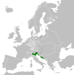
- 2013-04-14T01:33:26Z Alphathon 450x456 (853857 Bytes) == {{int:filedesc}} == {{Information |Description={{en|A blank Map of Europe circa 1789. This map also includes a border for the [[:en:Holy Roman Empire|Holy Roman Empire]]. Since there are so many small German states, they h
Uploaded with derivativeFX
Istoria de fix
Clica un data/ora per vide la fix en sua forma de alora.
| Data/Ora | Imajeta | Mesuras | Usor | Comenta | |
|---|---|---|---|---|---|
| aora | 22:20, 26 novembre 2021 | | 450 × 456 (927 KB) | Cplakidas | Fixing Venetian Albania, adding Cythera to Venice |
| 07:55, 17 otobre 2021 |  | 450 × 456 (803 KB) | Fenn-O-maniC | Fixed the Russo-Swedish border to match the Treaty of Åbo of 1743 | |
| 09:23, 27 febrero 2020 |  | 450 × 456 (821 KB) | Facquis | Clear map | |
| 17:16, 18 april 2013 |  | 450 × 456 (820 KB) | Alphathon | Various fixes | |
| 03:54, 14 april 2013 |  | 450 × 456 (802 KB) | Alphathon | == {{int:filedesc}} == {{Information |Description={{en|A map of the Republic of Venice circa 1789.}}{{de|Eine Landkarte die Republik Venedig c. 1989.}} |Source={{Derived from|Europe_1789.svg|display=5... |
Usas de fix
La paje seguente lia a esta fix:
Usa global de fix
La otra vicis seguente usa esta fix:
- Usa en azb.wikipedia.org
- Usa en bg.wikipedia.org
- Usa en ca.wikipedia.org
- Usa en ckb.wikipedia.org
- Usa en cs.wikipedia.org
- Usa en de.wikipedia.org
- Usa en el.wikipedia.org
- Usa en en.wikipedia.org
- Usa en eu.wikipedia.org
- Usa en fa.wikipedia.org
- Usa en fy.wikipedia.org
- Usa en he.wikipedia.org
- Usa en hi.wikipedia.org
- Usa en hr.wikipedia.org
- Usa en it.wikipedia.org
- Usa en ko.wikipedia.org
- Usa en lij.wikipedia.org
- Usa en lmo.wikipedia.org
- Usa en mk.wikipedia.org
- Usa en ml.wikipedia.org
- Usa en ms.wikipedia.org
- Usa en pl.wikipedia.org
- Usa en pt.wikipedia.org
- Usa en rue.wikipedia.org
- Usa en ru.wikipedia.org
- Usa en sk.wikipedia.org
- Usa en szl.wikipedia.org
- Usa en tr.wikipedia.org
- Usa en uk.wikipedia.org
- Usa en zh.wikipedia.org