
Fix:Red Sea topographic map-en.jpg

Grandia de esta previde: 367 × 600 pixeles Otra densias: 147 × 240 pixeles | 293 × 480 pixeles | 470 × 768 pixeles | 626 × 1,024 pixeles | 1,655 × 2,705 pixeles.
Fix orijinal (1,655 × 2,705 pixeles, grandia de fix: 1.63 MB, tipo MIME: image/jpeg)
Resoma
| Camera location | | View this and other nearby images on: OpenStreetMap |
|---|
| Descrive |
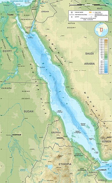
English: Topographic map in English of the Red Sea, UTM projection (WGS84 datum).
Note : for translation purpose, use the SVG version. Français : Carte topographique en anglais de la Mer Rouge, projection UTM (WGS84 datum).
|
||
| Data | |||
| Fonte | Own work (see complete description on Image:Red_Sea_topographic_map-en.svg) | ||
| Autor | Eric Gaba (Sting - fr:Sting) | ||
| Permete (Reusante esta fix) |
|
||
| Other versions |
[]
|


Lisensa
I, the copyright holder of this work, hereby publish it under the following licenses:

|
Permete es donada per copia, distribui e/o altera esta documento su la restrinjes de la GNU Free Documentation License, Varia 1.2 o cualce varia plu tarda publicida par la Free Software Foundation, sin partes nonvariante, sin testo de covrente fronte e sin testo de covrente retro. Un copia de la lisensa es incluida en la parte nomida GNU Free Documentation License. |
This file is licensed under the Creative Commons Attribution-Share Alike 4.0 International, 3.0 Unported, 2.5 Generic, 2.0 Generic and 1.0 Generic license.
- Tu es libre:
- per comparti – per copia, distribui e transmete la obra
- per remisca – per ajusta la obra
- Su la constrinjes seguente:
- atribui – Tu debe atribui la obra en la modo spesifada par la autor o lisensor (ma no en cualce modo cual sujesta ce el aproba tu o tua usa de la obra).
- share alike – Si tu altera, muta o developa plu esta obra, tu pote distribui la obra resultante sola su la mesma lisensa o un simil a esta.
Tu pote eleje la lisensa cual tu prefere
Istoria de fix
Clica un data/ora per vide la fix en sua forma de alora.
| Data/Ora | Imajeta | Mesuras | Usor | Comenta | |
|---|---|---|---|---|---|
| aora | 15:40, 29 desembre 2023 | | 1,655 × 2,705 (1.63 MB) | Sting | Without frame |
| 13:37, 19 julio 2010 |  | 1,655 × 2,705 (1.68 MB) | Sting | Color profile | |
| 04:47, 2 setembre 2008 |  | 1,655 × 2,705 (1.6 MB) | Sting | New standard colors ; bathymetry from ETOPO1 ; etc. | |
| 19:35, 3 april 2008 |  | 1,655 × 2,705 (1.67 MB) | Sting | Additional corrections | |
| 13:09, 3 april 2008 |  | 1,655 × 2,705 (1.71 MB) | Sting | Some names corrections ; some improvements | |
| 11:26, 3 april 2008 |  | 1,655 × 2,705 (1.67 MB) | Sting | Little correction | |
| 22:32, 2 april 2008 |  | 1,655 × 2,705 (1.7 MB) | Sting | {{Location|21|00|00|N|38|00|00|E|scale:10000000}} <br/> {{Information |Description={{en|Topographic map in English of the red Sea<br/>''Note :'' for translation purpose, use the SVG version.}} {{fr |
Usas de fix
La paje seguente lia a esta fix:
Usa global de fix
La otra vicis seguente usa esta fix:
- Usa en ami.wikipedia.org
- Usa en am.wikipedia.org
- Usa en ban.wikipedia.org
- Usa en bg.wikipedia.org
- Usa en bh.wikipedia.org
- Usa en bn.wikipedia.org
- Usa en ca.wikipedia.org
- Usa en ckb.wikipedia.org
- Usa en en.wikipedia.org
- Usa en eu.wikipedia.org
- Usa en fa.wikipedia.org
- Usa en fa.wikivoyage.org
- Usa en gu.wikipedia.org
- Usa en hak.wikipedia.org
- Usa en he.wikipedia.org
- Usa en he.wiktionary.org
- Usa en hi.wikipedia.org
- Usa en hr.wikipedia.org
- Usa en ilo.wikipedia.org
- Usa en incubator.wikimedia.org
- Usa en ja.wikipedia.org
- Usa en ja.wikibooks.org
- Usa en ka.wikipedia.org
- Usa en kcg.wikipedia.org
- Usa en kn.wikipedia.org
- Usa en ko.wikipedia.org
- Usa en lv.wikipedia.org
- Usa en mai.wikipedia.org
- Usa en ml.wikipedia.org
- Usa en ms.wikipedia.org
- Usa en my.wikipedia.org
- Usa en ne.wikipedia.org
- Usa en no.wikipedia.org
- Usa en olo.wikipedia.org
- Usa en pl.wikipedia.org
Mostra plu usas global de esta fix.