
Fix:Pleistocene north ice map.jpg

No densia plu alta es disponable.
Pleistocene_north_ice_map.jpg (250 × 417 pixeles, grandia de fix: 38 KB, tipo MIME: image/jpeg)
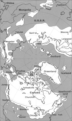
The maximum extent of glacial ice in the north polar area during Pleistocene time.
This image is in the public domain in the United States because it only contains materials that originally came from the United States Geological Survey, an agency of the United States Department of the Interior. For more information, see the official USGS copyright policy.
|
Istoria de fix
Clica un data/ora per vide la fix en sua forma de alora.
| Data/Ora | Imajeta | Mesuras | Usor | Comenta | |
|---|---|---|---|---|---|
| aora | 20:23, 11 junio 2005 | | 250 × 417 (38 KB) | Samulili | The maximum extent of glacial ice in the north polar area during Pleistocene time. {{PD-USGov-Interior-USGS}} http://pubs.usgs.gov/gip/continents/map.jpg |
Usas de fix
La paje seguente lia a esta fix:
Usa global de fix
La otra vicis seguente usa esta fix:
- Usa en bs.wikipedia.org
- Usa en ca.wikipedia.org
- Usa en cs.wikipedia.org
- Usa en en.wikipedia.org
- Usa en en.wikibooks.org
- Usa en eo.wikipedia.org
- Usa en es.wikipedia.org
- Usa en eu.wikipedia.org
- Usa en fa.wikipedia.org
- Usa en fi.wikipedia.org
- Usa en fi.wikibooks.org
- Usa en fr.wikipedia.org
- Usa en hr.wikipedia.org
- Usa en hu.wikipedia.org
- Usa en id.wikipedia.org
- Usa en it.wikipedia.org
- Usa en ja.wikipedia.org
- Usa en ka.wikipedia.org
- Usa en ru.wikipedia.org
- Usa en sh.wikipedia.org
- Usa en sl.wikipedia.org
- Usa en te.wikipedia.org
- Usa en th.wikipedia.org
- Usa en tr.wikipedia.org
- Usa en uk.wikipedia.org
- Usa en vi.wikipedia.org
- Usa en xmf.wikipedia.org
- Usa en zh.wikipedia.org