
Fix:Oceania Political Map (EEZ based).png
Grandia de esta previde: 800 × 495 pixeles Otra densias: 320 × 198 pixeles | 640 × 396 pixeles | 1,024 × 634 pixeles | 1,347 × 834 pixeles.
Fix orijinal (1,347 × 834 pixeles, grandia de fix: 51 KB, tipo MIME: image/png)
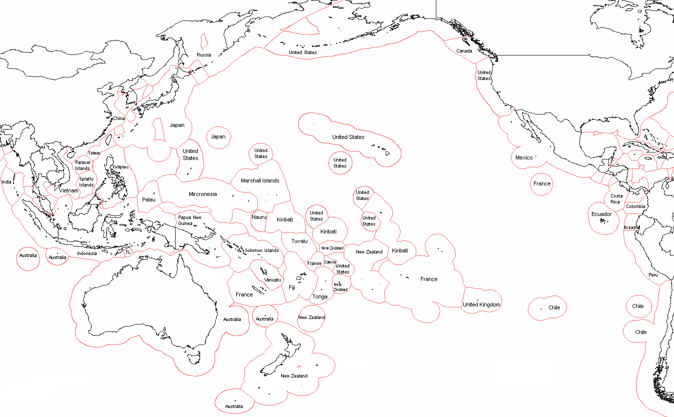
| Descrive | Political map of Oceania - based on EEZ borders | ||
| Data | |||
| Fonte | I, Alinor (talk) created this work entirely by myself. | ||
| Autor | Alinor (talk) | ||
| Permete (Reusante esta fix) |
I, the copyright holder of this work, hereby publish it under the following licenses: Esta fix es lisensada su la lisensa Attribution-Share Alike 3.0 Unported de Creative Commons.
Tu pote eleje la lisensa cual tu prefere |
||
| Other versions | based on File:Realm of New Zealand Exclusive Economic Zones.png |

.png)
Istoria de fix
Clica un data/ora per vide la fix en sua forma de alora.
| Data/Ora | Imajeta | Mesuras | Usor | Comenta | |
|---|---|---|---|---|---|
| aora | 20:47, 2 junio 2018 | | 1,347 × 834 (51 KB) | Janitoalevic | . |
| 20:33, 2 junio 2018 |  | 1,347 × 834 (51 KB) | Janitoalevic | Updated Chile-Peru maritime border | |
| 13:26, 21 setembre 2013 |  | 1,347 × 834 (84 KB) | Avenue | Reverted to version as of 05:59, 2 February 2012 - Tokelau isn't Niue | |
| 21:35, 20 april 2012 |  | 1,347 × 834 (75 KB) | Spesh531 | niue and cook islands | |
| 05:59, 2 febrero 2012 |  | 1,347 × 834 (84 KB) | Che829 | Reverted to version as of 13:03, 28 September 2010 Deceiving edit summary by 23prootie. The UNCLOS (http://www.un.org/Depts/los/convention_agreements/texts/unclos/closindx.htm) doesn't have any statements to broaden the EEZs of Japan and the Philippines. | |
| 00:13, 1 junio 2011 |  | 1,347 × 834 (99 KB) | 23prootie~commonswiki | Updated. Source: UNCLOS. | |
| 13:03, 28 setembre 2010 |  | 1,347 × 834 (84 KB) | Frank50 s | {{Information |Description = Political map of Oceania - based on EEZ borders |Source = I,Alinor (talk)) created this work entirely by myself. |Date = 17.8 |
Usas de fix
La paje seguente lia a esta fix:
Usa global de fix
La otra vicis seguente usa esta fix:
- Usa en ar.wikipedia.org
- Usa en ca.wikipedia.org
- Usa en el.wikipedia.org
- Usa en en.wikipedia.org
- Usa en eo.wikipedia.org
- Usa en es.wikipedia.org
- Usa en fo.wikipedia.org
- Usa en fr.wikipedia.org
- Usa en gl.wikipedia.org
- Usa en it.wikipedia.org
- Usa en la.wikipedia.org
- Usa en mk.wikipedia.org
- Usa en sd.wikipedia.org
.png)