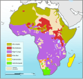
Fix:Languages of Africa map.svg

Grandia de esta previde PNG de esta fix SVG: 629 × 599 pixeles. Otra densias: 252 × 240 pixeles | 504 × 480 pixeles | 806 × 768 pixeles | 1,075 × 1,024 pixeles | 2,150 × 2,048 pixeles | 1,534 × 1,461 pixeles.
Fix orijinal (fix svg, densia: 1,534 × 1,461 pixeles, grandia: 750 KB)
Istoria de fix
Clica un data/ora per vide la fix en sua forma de alora.
| Data/Ora | Imajeta | Mesuras | Usor | Comenta | |
|---|---|---|---|---|---|
| aora | 03:17, 16 desembre 2010 |  | 1,534 × 1,461 (750 KB) | Brianski | Color Bioko Island (Equatorial Guinea), as well as São Tome and Principe, acccording to ethnologue. Not sure what color to use for Annobón, so I left it blank. |
| 03:05, 16 desembre 2010 |  | 1,534 × 1,461 (750 KB) | Brianski | It was really hard to tell water from Khoi-San and Nilo-Saharan, particularly confusing in the Great Lakes area, so I chose a new color scheme. | |
| 03:04, 16 desembre 2010 |  | 1,534 × 1,461 (750 KB) | Brianski | It was really hard to tell great lakes from Khoi-San and Nilo-Saharan, particularly confusing in the Great Lakes area, so I chose a new color scheme. | |
| 16:31, 20 agosto 2010 |  | 1,534 × 1,461 (750 KB) | P. S. Burton | coloured non-African areas 10% grey. They were the same colour as the "sparsely populated areas". | |
| 11:09, 11 janero 2010 |  | 1,534 × 1,461 (750 KB) | Brianski | changed to mark all of madagascar in yellow, as madagascar's malagasy-speaking population is not concentrated in the north and west as this map implies - see: http://maps.nationmaster.com/country/ma/1 http://www.ethnologue.com/show_map.asp?name=MG&seq=10 | |
| 08:33, 8 agosto 2009 |  | 1,534 × 1,461 (753 KB) | Seb az86556 | adjustment (Namibia) | |
| 07:32, 8 agosto 2009 |  | 1,534 × 1,461 (765 KB) | Seb az86556 | {{Information |Description={{en|1=Languages of Africa map}} |Source=Own work by uploader |Author=Seb az86556 |Date=2009-08-08 |Permission= |other_versions= }} Category:Linguistic maps of Africa Category:SVG linguistic maps [[ |
Usas de fix
La paje seguente lia a esta fix:
Usa global de fix
La otra vicis seguente usa esta fix:
- Usa en ar.wikipedia.org
- Usa en ca.wikipedia.org
- Usa en en.wikipedia.org
- Usa en fr.wikipedia.org
- Usa en fr.wiktionary.org
- Usa en lv.wikipedia.org
- Usa en nn.wikipedia.org
- Usa en pnb.wikipedia.org
- Usa en pt.wikipedia.org
- Usa en ru.wikipedia.org
- Usa en uk.wikipedia.org


