
Fix:Kaart Hanzesteden en handelsroutes.jpg
Grandia de esta previde: 800 × 440 pixeles Otra densias: 320 × 176 pixeles | 640 × 352 pixeles | 1,176 × 647 pixeles.
Fix orijinal (1,176 × 647 pixeles, grandia de fix: 853 KB, tipo MIME: image/jpeg)
Resoma
| Descrive |
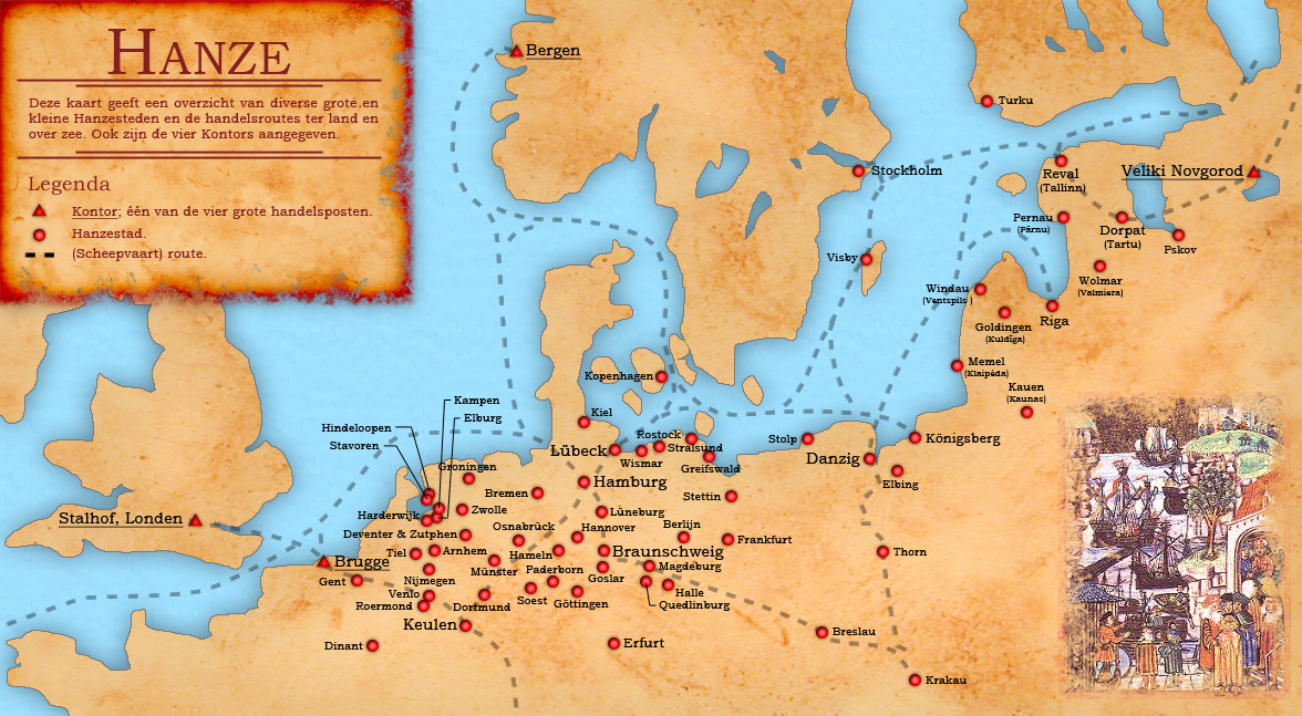
English: Dutch map of the different small and large Hanseatic Leage cities and trade routes.
Nederlands: Nederlandstalige kaart van de verschillende grote en kleine Hanzesteden en de handelsroutes. Hierop ontbreekt Oldenzaal. |
| Data | |
| Fonte | eigen werk (own work) + Base map from: File:Europein1328.png by Afterword |
| Autor | Doc Brown |
Lisensa
I, the copyright holder of this work, hereby publish it under the following licenses:

|
Permete es donada per copia, distribui e/o altera esta documento su la restrinjes de la GNU Free Documentation License, Varia 1.2 o cualce varia plu tarda publicida par la Free Software Foundation, sin partes nonvariante, sin testo de covrente fronte e sin testo de covrente retro. Un copia de la lisensa es incluida en la parte nomida GNU Free Documentation License. |
This file is licensed under the Creative Commons Attribution-Share Alike 3.0 Unported, 2.5 Generic, 2.0 Generic and 1.0 Generic license.
- Tu es libre:
- per comparti – per copia, distribui e transmete la obra
- per remisca – per ajusta la obra
- Su la constrinjes seguente:
- atribui – Tu debe atribui la obra en la modo spesifada par la autor o lisensor (ma no en cualce modo cual sujesta ce el aproba tu o tua usa de la obra).
- share alike – Si tu altera, muta o developa plu esta obra, tu pote distribui la obra resultante sola su la mesma lisensa o un simil a esta.
Tu pote eleje la lisensa cual tu prefere
Istoria de fix
Clica un data/ora per vide la fix en sua forma de alora.
| Data/Ora | Imajeta | Mesuras | Usor | Comenta | |
|---|---|---|---|---|---|
| aora | 14:40, 13 desembre 2008 | | 1,176 × 647 (853 KB) | Doc Brown | {{Information |Description={{en|1=Dutch map of the different small and large Hanseatic Leage cities and trade routes.}} {{nl|1=Nederlandstalige kaart van de verschillende grote en kleine Hanzesteden en de handelsroutes.}} |Source=eigen werk (own work) + B |
Usas de fix
La paje seguente lia a esta fix:
Usa global de fix
La otra vicis seguente usa esta fix:
- Usa en cs.wikipedia.org
- Usa en el.wikipedia.org
- Usa en en.wikipedia.org
- Usa en eo.wikipedia.org
- Usa en es.wikipedia.org
- Usa en fi.wikipedia.org
- Usa en fy.wikipedia.org
- Usa en la.wikipedia.org
- Usa en nds-nl.wikipedia.org
- Usa en nl.wikipedia.org
- Usa en ru.wikipedia.org
- Usa en sl.wikipedia.org
- Usa en smn.wikipedia.org
- Usa en tl.wikipedia.org
- Usa en zh-yue.wikipedia.org
- Usa en zh.wikipedia.org