
Fix:Greatbasinmap.png

Grandia de esta previde: 536 × 599 pixeles Otra densias: 215 × 240 pixeles | 430 × 480 pixeles | 687 × 768 pixeles | 916 × 1,024 pixeles | 1,500 × 1,676 pixeles.
Fix orijinal (1,500 × 1,676 pixeles, grandia de fix: 7.21 MB, tipo MIME: image/png)
Resoma
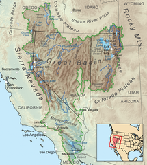
| Descrive | Map showing the Great Basin drainage basin as defined hydrologically. |
| Data | |
| Fonte | Obra propre, Elevation data from SRTM, all other features from the National Atlas. Rand McNally, The New International Atlas, 1993 used as reference. |
| Autor | Kmusser |
| Other versions |
 |
Lisensa
I, the copyright holder of this work, hereby publish it under the following license:
Esta fix es lisensada su la lisensa Attribution-Share Alike 3.0 Unported de Creative Commons.
- Tu es libre:
- per comparti – per copia, distribui e transmete la obra
- per remisca – per ajusta la obra
- Su la constrinjes seguente:
- atribui – Tu debe atribui la obra en la modo spesifada par la autor o lisensor (ma no en cualce modo cual sujesta ce el aproba tu o tua usa de la obra).
- share alike – Si tu altera, muta o developa plu esta obra, tu pote distribui la obra resultante sola su la mesma lisensa o un simil a esta.
Istoria de fix
Clica un data/ora per vide la fix en sua forma de alora.
| Data/Ora | Imajeta | Mesuras | Usor | Comenta | |
|---|---|---|---|---|---|
| aora | 22:25, 4 setembre 2020 | | 1,500 × 1,676 (7.21 MB) | Nwbeeson | Added boundary map. Second attempt to upload the image. |
| 22:21, 4 setembre 2020 |  | 1,500 × 1,676 (7.21 MB) | Nwbeeson | Added boundary line. | |
| 16:58, 11 desembre 2010 |  | 1,500 × 1,676 (3.64 MB) | Kmusser | Added Goose Lake | |
| 20:37, 17 novembre 2010 |  | 1,500 × 1,676 (3.23 MB) | Kmusser | == Summary == {{Information |Description=Map showing the Great Basin drainage basin as defined hydrologically. |Source={{own}}, Elevation data from SRTM, all other features from the [[:w:National |
Usas de fix
La pajes seguente lia a esta fix:
Usa global de fix
La otra vicis seguente usa esta fix:
- Usa en ar.wikipedia.org
- Usa en ast.wikipedia.org
- Usa en az.wikipedia.org
- Usa en bg.wikipedia.org
- Usa en bn.wikipedia.org
- Usa en bs.wikipedia.org
- Usa en ckb.wikipedia.org
- Usa en cs.wikipedia.org
- Usa en de.wikipedia.org
- Usa en es.wikipedia.org
- Usa en et.wikipedia.org
- Usa en fa.wikipedia.org
- Usa en fi.wikipedia.org
- Usa en fr.wikipedia.org
- Usa en fy.wikipedia.org
- Usa en he.wikipedia.org
- Usa en id.wikipedia.org
- Usa en is.wikipedia.org
- Usa en it.wikipedia.org
- Usa en ja.wikipedia.org
- Usa en ka.wikipedia.org
- Usa en kk.wikipedia.org
- Usa en kn.wikipedia.org
- Usa en ko.wikipedia.org
- Usa en li.wikipedia.org
- Usa en lt.wikipedia.org
- Usa en mk.wikipedia.org
- Usa en ml.wikipedia.org
- Usa en mr.wikipedia.org
- Usa en nl.wikipedia.org
- Usa en nn.wikipedia.org
- Usa en pa.wikipedia.org
- Usa en pl.wikipedia.org
- Usa en pnb.wikipedia.org
- Usa en pt.wikipedia.org
- Usa en ru.wikipedia.org
- Usa en simple.wikipedia.org
- Usa en sq.wikipedia.org
- Usa en sw.wikipedia.org
- Usa en ta.wikipedia.org
- Usa en tr.wikipedia.org
- Usa en uk.wikipedia.org
- Usa en uz.wikipedia.org
- Usa en vi.wikipedia.org
- Usa en zh.wikipedia.org
Mostra plu usas global de esta fix.