
Fix:Geopolitical map of Canada.png

Grandia de esta previde: 680 × 599 pixeles Otra densias: 272 × 240 pixeles | 545 × 480 pixeles | 872 × 768 pixeles | 1,162 × 1,024 pixeles | 1,280 × 1,128 pixeles.
Fix orijinal (1,280 × 1,128 pixeles, grandia de fix: 545 KB, tipo MIME: image/png)
Resoma
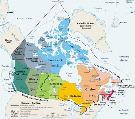
Español: Mapa político de Canadá!, con 10 provincias y 3 territorios.
This is a geopolitical map of Canada, drawn by User:E Pluribus Anthony. Source: en:Image:Map Canada political-geo.png
| This work has been released into the public domain by its author, E Pluribus Anthony at English Vicipedia. This applies worldwide. In some countries this may not be legally possible; if so: E Pluribus Anthony grants anyone the right to use this work for any purpose, without any conditions, unless such conditions are required by law. |
| Annotations | This image is annotated: View the annotations at Commons |
Istoria de fix
Clica un data/ora per vide la fix en sua forma de alora.
| Data/Ora | Imajeta | Mesuras | Usor | Comenta | |
|---|---|---|---|---|---|
| aora | 16:32, 5 maio 2020 | | 1,280 × 1,128 (545 KB) | Leonel Sohns | Edited |
| 02:18, 10 april 2006 |  | 1,280 × 1,128 (493 KB) | E Pluribus Anthony~commonswiki | Map: Canada – geopolitical | |
| 18:31, 29 marto 2006 |  | 1,280 × 1,128 (494 KB) | Anchjo | This is a geopolitical map of Canada, drawn by en:User:E Pluribus Anthony. Source: en:Image:Map Canada political-geo.png {{PD-user-wikimedia|E Pluribus Anthony|en}} Category:Maps of Canada |
Usas de fix
La paje seguente lia a esta fix:
Usa global de fix
La otra vicis seguente usa esta fix:
- Usa en ast.wikipedia.org
- Usa en cs.wikipedia.org
- Usa en de.wikipedia.org
- Usa en diq.wikipedia.org
- Usa en en.wikipedia.org
- Usa en eo.wikipedia.org
- Usa en es.wikipedia.org
- Usa en fr.wikipedia.org
- Usa en gl.wikipedia.org
- Usa en it.wikipedia.org
- Usa en ko.wikipedia.org
- Usa en mt.wikipedia.org
- Usa en mzn.wikipedia.org
- Usa en pl.wikipedia.org
- Usa en sw.wikipedia.org