
Fix:Former Yugoslavia 2008.PNG

Grandia de esta previde: 800 × 527 pixeles Otra densias: 320 × 211 pixeles | 640 × 421 pixeles | 1,024 × 674 pixeles | 1,280 × 842 pixeles | 1,887 × 1,242 pixeles.
Fix orijinal (1,887 × 1,242 pixeles, grandia de fix: 114 KB, tipo MIME: image/png)

|
This map image could be re-created using vector graphics as an SVG file. This has several advantages; see Commons:Media for cleanup for more information. If an SVG form of this image is available, please upload it and afterwards replace this template with
{{vector version available|new image name}}.
It is recommended to name the SVG file “Former Yugoslavia 2008.svg”—then the template Vector version available (or Vva) does not need the new image name parameter. |
Resoma
| Descrive |
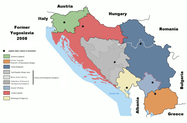
English: Map of former Yugoslavia including Kosovo independence.
Deutsch: Karte des früheren Jugoslawiens einschließlich der Unabhängigkeit des Kosovo. |
| Data | |
| Fonte | derived from File:Former Yugoslavia 2006.png by Dudemanfellabra at en.wikipedia |
| Autor | Ijanderson977 |
| Permete (Reusante esta fix) |
Released under the GNU Free Documentation License. |
| Other versions |
|


Transferred from en:wikipedia to Commons by User:Tieum512 using CommonsHelper.
More versions on en.wikipedia see Original upload log below.
Lisensa

|
Permete es donada per copia, distribui e/o altera esta documento su la restrinjes de la GNU Free Documentation License, Varia 1.2 o cualce varia plu tarda publicida par la Free Software Foundation, sin partes nonvariante, sin testo de covrente fronte e sin testo de covrente retro. Un copia de la lisensa es incluida en la parte nomida GNU Free Documentation License. |
| Esta fix es lisensada su la lisensa Attribution-Share Alike 3.0 Unported de Creative Commons. | ||
| ||
| This licensing tag was added to this file as part of the GFDL licensing update. |
Original upload log
The original description page was here. All following user names refer to en.wikipedia.
- 2009-02-19 05:22 Српска Крајина 1887×1192× (131504 bytes)
- 2008-07-06 20:01 Ijanderson977 1887×1192× (130802 bytes) Corrected spelling from Albanian to English.
- 2008-07-04 00:35 Hoshie 1887×1192× (122315 bytes) Give Kosovo own color due to the change in status.
- 2008-03-18 23:43 Dudemanfellabra 1887×1192× (83000 bytes) Map of former Yugoslavia edited to include Kosovo independence. March 2008 Author: Floyd Maseda (Dudemanfellabra). Original image: [http://en.wikipedia.org/wiki/Image:Former_Yugoslavia_2006.png] June 2006 Author: Paweł Goleniowski (swPawel)
Istoria de fix
Clica un data/ora per vide la fix en sua forma de alora.
| Data/Ora | Imajeta | Mesuras | Usor | Comenta | |
|---|---|---|---|---|---|
| aora | 19:12, 26 otobre 2022 | | 1,887 × 1,242 (114 KB) | Ghostantinos | fix |
| 21:06, 26 agosto 2021 |  | 1,887 × 1,242 (105 KB) | Santasa99 | more npov | |
| 13:53, 27 julio 2019 |  | 1,887 × 1,242 (95 KB) | Drax90 | New updated version | |
| 19:05, 22 febrero 2019 |  | 1,887 × 1,192 (136 KB) | Koreanovsky | Reverted to version as of 10:29, 21 February 2019 (UTC) | |
| 12:06, 21 febrero 2019 |  | 1,887 × 1,242 (95 KB) | Drax90 | New color scheme | |
| 10:29, 21 febrero 2019 |  | 1,887 × 1,192 (136 KB) | UglyGoat | Reverted to version as of 17:08, 4 February 2019 (UTC) | |
| 17:44, 12 febrero 2019 |  | 1,887 × 1,242 (95 KB) | Drax90 | Fixed version of the map | |
| 17:08, 4 febrero 2019 |  | 1,887 × 1,192 (136 KB) | Koreanovsky | There is no official border between Herzeg-Bosnia and FBiH; Reverted to version as of 23:01, 18 December 2011 (UTC) | |
| 16:52, 19 desembre 2018 |  | 1,887 × 1,242 (97 KB) | Drax90 | Latest version with new colors | |
| 18:44, 24 novembre 2018 |  | 1,887 × 1,242 (149 KB) | Drax90 | Updated version |
Usas de fix
La paje seguente lia a esta fix:
Usa global de fix
La otra vicis seguente usa esta fix:
- Usa en ar.wikipedia.org
- Usa en bg.wikipedia.org
- Usa en ca.wikipedia.org
- Usa en cs.wikipedia.org
- Usa en de.wikipedia.org
- Usa en de.wikibooks.org
- Usa en el.wikipedia.org
- Usa en en.wikipedia.org
- Usa en es.wikipedia.org
- Usa en eu.wikipedia.org
- Usa en fr.wikipedia.org
- Usa en gd.wikipedia.org
- Usa en he.wikipedia.org
- Usa en hyw.wikipedia.org
- Usa en it.wikipedia.org
- Usa en ja.wikipedia.org
- Usa en kn.wikipedia.org
- Usa en ko.wikipedia.org
- Usa en mk.wikipedia.org
- Usa en mr.wikipedia.org
- Usa en nl.wikipedia.org
- Usa en pnb.wikipedia.org
- Usa en pt.wikipedia.org
- Usa en rm.wikipedia.org
- Usa en ro.wikipedia.org
- Usa en ru.wikipedia.org
- Usa en sh.wikipedia.org
- Usa en sl.wikipedia.org
- Usa en sr.wikipedia.org
- Usa en ta.wikipedia.org
- Usa en te.wikipedia.org
- Usa en th.wikipedia.org
- Usa en tr.wikipedia.org
- Usa en ur.wikipedia.org
Mostra plu usas global de esta fix.