
Fix:First Irish farmers hut, Irish National Heritage Park - geograph.org.uk - 1252729.jpg
No densia plu alta es disponable.
First_Irish_farmers_hut,_Irish_National_Heritage_Park_-_geograph.org.uk_-_1252729.jpg (640 × 480 pixeles, grandia de fix: 128 KB, tipo MIME: image/jpeg)
Resoma
| Descrive |
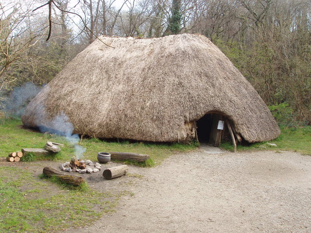
English: First Irish farmers hut, Irish National Heritage Park Around 4000 B.C. farmers came to Ireland and made permanent houses, raised livestock, grew cereals, and made pottery. In this exhibit in the Heritage Park a fire is lit on most days, some staff are in costumes of the various periods of Irish history, and on some days there are re-enactments of ancient life.
Première cabane d'agriculteurs irlandais. Le parc national du patrimoine irlandais vers 4000 avant J.-C., les agriculteurs sont venus en Irlande et ont construit des maisons permanentes, élevaient du bétail, ont planté des céréales, et faisaient de la poterie. Dans cette exposition dans le parc du patrimoine, un feu est allumé la plupart du temps, certains membres du personnel sont en costumes des différentes périodes de l'histoire irlandaise, et, certains jours, il y a des reconstitutions de la vie antique. |
| Data | |
| Fonte | From geograph.org.uk |
| Autor | David Hawgood |
| Atribui (required by the license) | David Hawgood / First Irish farmers hut, Irish National Heritage Park / |
| Camera location | | View this and other nearby images on: OpenStreetMap |
|---|
_heading:90.00&language=lfn)
| Object location | | View this and other nearby images on: OpenStreetMap |
|---|
_heading:90.00&language=lfn)
Lisensa

|
This image was taken from the Geograph project collection. See this photograph's page on the Geograph website for the photographer's contact details. The copyright on this image is owned by David Hawgood and is licensed for reuse under the Creative Commons Attribution-ShareAlike 2.0 license.
|
This file is licensed under the Creative Commons Attribution-Share Alike 2.0 Generic license.
Atribui: David Hawgood
- Tu es libre:
- per comparti – per copia, distribui e transmete la obra
- per remisca – per ajusta la obra
- Su la constrinjes seguente:
- atribui – Tu debe atribui la obra en la modo spesifada par la autor o lisensor (ma no en cualce modo cual sujesta ce el aproba tu o tua usa de la obra).
- share alike – Si tu altera, muta o developa plu esta obra, tu pote distribui la obra resultante sola su la mesma lisensa o un simil a esta.
Istoria de fix
Clica un data/ora per vide la fix en sua forma de alora.
| Data/Ora | Imajeta | Mesuras | Usor | Comenta | |
|---|---|---|---|---|---|
| aora | 19:56, 26 febrero 2011 | | 640 × 480 (128 KB) | GeographBot | == {{int:filedesc}} == {{Information |description={{en|1=First Irish farmers hut, Irish National Heritage Park Around 4000 B.C. farmers came to Ireland and made permanent houses, raised livestock, grew cereals, and made pottery. In this exhibit in the Her |
Usas de fix
La paje seguente lia a esta fix:
Usa global de fix
La otra vicis seguente usa esta fix:
- Usa en en.wikipedia.org
- Usa en ga.wikipedia.org
- Usa en nl.wikipedia.org
- Usa en pl.wikipedia.org
- Usa en pt.wikipedia.org
- Usa en sv.wikibooks.org