
Fix:Colonial Africa 1913 map.svg

Grandia de esta previde PNG de esta fix SVG: 644 × 600 pixeles. Otra densias: 258 × 240 pixeles | 515 × 480 pixeles | 824 × 768 pixeles | 1,099 × 1,024 pixeles | 2,198 × 2,048 pixeles | 1,390 × 1,295 pixeles.
Fix orijinal (fix svg, densia: 1,390 × 1,295 pixeles, grandia: 660 KB)
BEL
|
GER
|
ESP
|
FRA
|
GBR
|
ITA
|
PRT
|
Independent
| |
|---|---|---|---|---|---|---|---|---|
العربية: |
بلجيكا | ألمانيا | اسبانيا | فرنسا | بريطانيا | إيطاليا | البرتغال | |
Azərbaycanca: |
Belçika | Almaniya | İspaniya | Fransa | Böyük Britaniya | İtaliya | Portuqaliya | |
Беларуская: |
Бельгія | Германія | Іспанія | Францыя | Вялікабрытанія | Італія | Партугалія | |
Български: |
Белгия | Германия | Испания | Франция | Великобритания | Италия | Португалия | |
বাংলা: |
বেলজিয়াম | জার্মানি | স্পেন | ফ্রান্স | যুক্তরাজ্য | ইতালি | পর্তুগাল | |
Català: |
Bèlgica | Alemanya | Espanya | França | Gran Bretanya | Itàlia | Portugal | |
Čeština: |
Belgie | Německo | Španělsko | Francie | Velká Británie | Itálie | Portugalsko | |
Cymraeg: |
Gwlad Belg | Yr Almaen | Sbaen | Ffrainc | Prydain Fawr | Yr Eidal | Portiwgal | |
Dansk: |
Belgien | Tyskland | Spanien | Frankrig | Storbritannien | Italien | Portugal | |
Deutsch: |
Belgien | Deutschland | Spanien | Frankreich | Großbritannien | Italien | Portugal | Unabhängige Staaten |
Ελληνικά: |
Βέλγιο | Γερμανία | Ισπανία | Γαλλία | Μεγάλη Βρετανία | Ιταλία | Πορτογαλία | |
English: |
Belgium | Germany | Spain | France | United Kingdom | Italy | Portugal | Independent States |
Esperanto: |
Belgio | Germanio | Hispanio | Francio | Britio | Italio | Portugalio | |
Español: |
Bélgica | Alemania | España | Francia | Gran Bretaña | Italia | Portugal | Estados independientes |
Eesti: |
Belgia | Saksamaa | Hispaania | Prantsusmaa | Suurbritannia | Itaalia | Portugal | |
Euskara: |
Belgika | Alemania | Espainia | Frantzia | Britainia Handia | Italia | Portugal | |
Suomi: |
Belgia | Saksa | Espanja | Ranska | Iso-Britannia | Italia | Portugalia | |
Français : |
Belgique | Allemagne | Espagne | France | Grande-Bretagne | Italie | Portugal | États indépendants |
Gaeilge: |
An Bheilg | An Ghearmáin | An Spáinn | An Fhrainc | An Ríocht Aontaithe | An Iodáil | An Phortáingeil | |
Galego: |
Bélxica | Alemaña | España | Francia | Gran Bretaña | Italia | Portugal | |
Hrvatski: |
Belgija | Njemačka | Španjolska | Francuska | Velika Britanija | Italija | Portugal | |
Magyar: |
Belgium | Németország | Spanyolország | Franciország | Nagy-Britania | Olaszország | Portugália | |
Հայերեն: |
Բելգիա | Գերմանիա | Իսպանիա | Ֆրանսիա | Միացյալ Թագավորություն | Իտալիա | Պորտուգալիա | |
Bahasa Indonesia: |
Belgia | Jerman | Spanyol | Prancis | Britania Raya | Ítalia | Portugal | Negara independen |
Íslenska: |
Belgía | Þýskaland | Spánn | Frakkland | Stóra Bretland | Ítalía | Portúgal | |
Italiano: |
Belgio | Germania | Spagna | Francia | Regno Unito | Italia | Portogallo | |
ქართული: |
ბელგია | გერმანია | ესპანეთი | საფრანგეთი | გაერთიანებული სამეფო | იტალია | პორტუგალია | |
한국어: |
벨기에 | 독일 | 스페인 | 프랑스 | 영국 | 이탈리아 | 포르투갈 | |
Lietuvių: |
Belgija | Vokietija | Ispanija | Prancūzija | D. Britanija | Italija | Portugalija | |
Latviešu: |
Beļģija | Vācija | Spānija | Francija | Lielbritānija | Itālija | Portugāle | |
Македонски: |
Белгија | Германија | Шпанија | Франција | Велика Британија | Италија | Португалија | |
Malti: |
Belġju | Ġermanja | Spanja | Franza | Gran Brittanja | Italja | Portugall | |
Nederlands: |
België | Duitsland | Spanje | Frankrijk | Groot-Brittannië | Italië | Portugal | Onafhankelijke gebieden |
Norsk bokmål: |
Belgia | Tyskland | Spania | Frankrike | Storbritannia | Italia | Portugal | |
Polski: |
Belgia | Niemcy | Hiszpania | Francja | Wielka Brytania | Włochy | Portugalia | |
Português: |
Bélgica | Alemanha | Espanha | França | Grã-Bretanha | Itália | Portugal | Estados independentes |
Română: |
Belgia | Germania | Spania | Franţa | Regatul Unit | Italia | Portugalia | |
Русский: |
Бельгия | Германия | Испания | Франция | Великобритания | Италия | Португалия | |
Slovenčina: |
Belgicko | Nemecko | Španielsko | Francúzsko | Veľká Británia | Taliansko | Portugalsko | |
Slovenščina: |
Belgija | Nemčija | Španija | Francija | Velika Britanija | Italija | Portugalska | |
Shqip: |
Belgjika | Gjermanija | Spanja | Franca | Britanisë së Madhe | Italia | Portugalia | |
Српски / srpski: |
Белгија | Немачка | Шпанија | Француска | Велика Британија | Италија | Португалија | |
Svenska: |
Belgien | Tyskland | Spanien | Frankrike | Storbritannien | Italien | Portugal | |
Kiswahili: |
Ubelgiji | Ujerumani | Hispania | Ufaransa | Ufalme wa Muungano | Italia | Ureno | |
Türkçe: |
Belçika | Almanya | İspanya | Fransa | Büyük Britanya | İtalya | Portekiz | |
Українська: |
Бельгія | Німеччина | Іспанія | Франція | Велика Британія | Італія | Португалія | |
Tiếng Việt: |
Bỉ | Đức | Tây Ban Nha | Pháp | Anh | Ý | Bồ Đào Nha | |
中文: |
比利时 | 德国 | 西班牙 | 法国 | 英国 | 意大利 | 葡萄牙 |
Resoma
| Descrive |
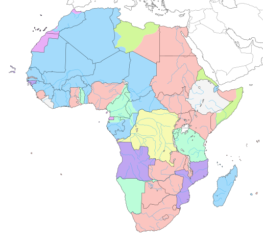
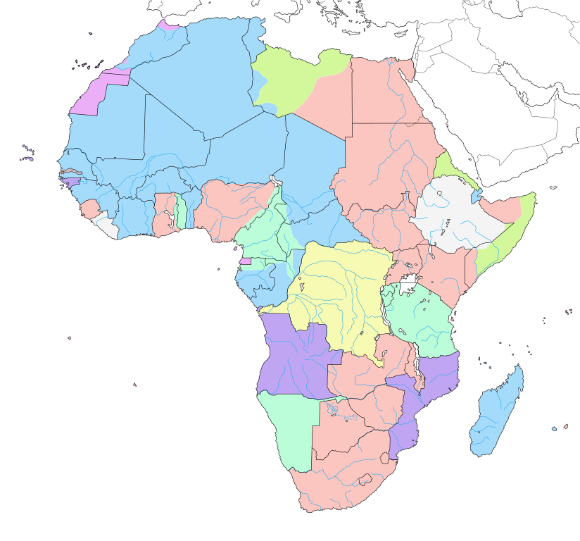
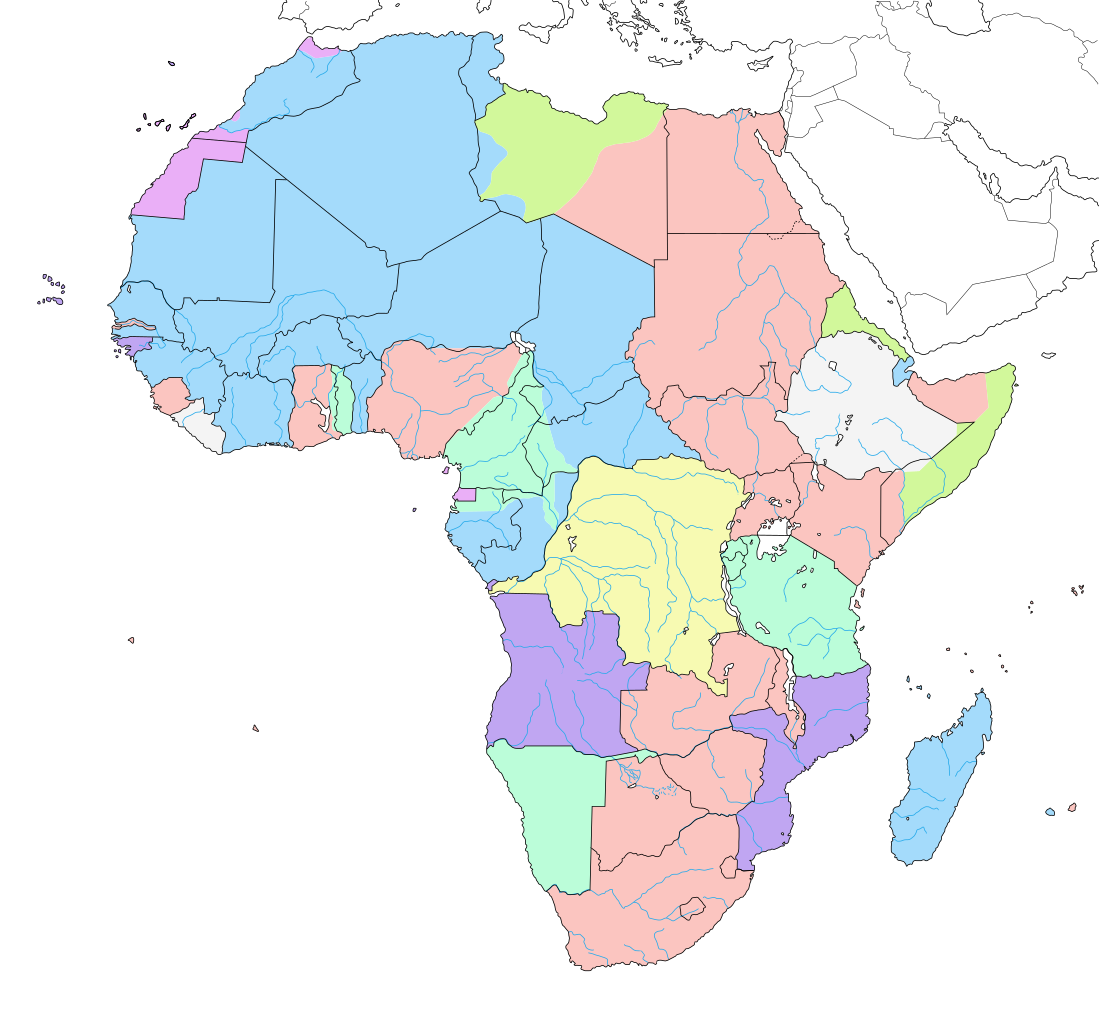
English: Map of colonial Africa as in 1913, with modern borders.
Note: The limits of the areas of control may not be perfectly accurate due to the imprecision of the reference maps. Deutsch: Karte des kolonialen Afrikas von 1913 mit modernen Grenzen.
Notiz: Die Grenzen der Kontrollbereiche sind aufgrund der Ungenauigkeit der Referenzkarten möglicherweise nicht ganz genau. Italiano: Mappa dell'Africa coloniale come nel 1913, con confini moderni.
Nota: I limiti delle aree di controllo potrebbero non essere perfettamente precisi a causa dell'imprecisione delle mappe di riferimento. Español: Mapa del África colonial como en 1913, con fronteras modernas.
Nota: Los límites de las áreas de control pueden no ser perfectamente precisos debido a la imprecisión de los mapas de referencia. Français : Carte de l'Afrique coloniale en 1913, avec frontières modernes. Note : Les limites des zones de contrôle peuvent ne pas être tout à fait exactes en raison de l'imprécision des cartes de référence utilisées. |
||
| Data | junio 2007, updated/corrected 2011-07 | ||
| Fonte |
Obra propre (Original text: Own work ;)
|
||
| Autor | Eric Gaba (Sting - fr:Sting) | ||
| Permete (Reusante esta fix) |
|
||
| Other versions |
[]
|
||
| SVG genesis |


.svg)

_ast.svg)


-es.svg)
_mapa.png)

_eu.svg)


.svg)

.jpg)


-sr.png)


.svg)

.svg)

Lisensa
Eric Gaba, the copyright holder of this work, hereby publishes it under the following licenses:

|
Permete es donada per copia, distribui e/o altera esta documento su la restrinjes de la GNU Free Documentation License, Varia 1.2 o cualce varia plu tarda publicida par la Free Software Foundation, sin partes nonvariante, sin testo de covrente fronte e sin testo de covrente retro. Un copia de la lisensa es incluida en la parte nomida GNU Free Documentation License. |
| Esta fix es lisensada su la lisensa Attribution-Share Alike 3.0 Unported de Creative Commons. | ||
| Atribui: Eric Gaba – Wikimedia Commons user: Sting | ||
| ||
| This licensing tag was added to this file as part of the GFDL licensing update. |
This file is licensed under the Creative Commons Attribution-Share Alike 2.5 Generic license.
Atribui: Eric Gaba – Wikimedia Commons user: Sting
- Tu es libre:
- per comparti – per copia, distribui e transmete la obra
- per remisca – per ajusta la obra
- Su la constrinjes seguente:
- atribui – Tu debe atribui la obra en la modo spesifada par la autor o lisensor (ma no en cualce modo cual sujesta ce el aproba tu o tua usa de la obra).
- share alike – Si tu altera, muta o developa plu esta obra, tu pote distribui la obra resultante sola su la mesma lisensa o un simil a esta.
Tu pote eleje la lisensa cual tu prefere
Istoria de fix
Clica un data/ora per vide la fix en sua forma de alora.
| Data/Ora | Imajeta | Mesuras | Usor | Comenta | |
|---|---|---|---|---|---|
| aora | 14:29, 24 april 2019 | | 1,390 × 1,295 (660 KB) | Sting | Added surrounding landmasses ; waterbodies in white ; colour adjustment |
| 13:29, 5 julio 2018 |  | 1,390 × 1,295 (586 KB) | M3tainfo | Black borders with stroke width and removed local file refs | |
| 00:36, 3 marto 2014 |  | 1,390 × 1,295 (587 KB) | Sting | Reverted to version as of 13:06, 19 December 2013 | |
| 16:07, 2 marto 2014 |  | 1,390 × 1,295 (590 KB) | Knyaz-1988 | New version | |
| 16:05, 2 marto 2014 |  | 1,390 × 1,295 (587 KB) | Knyaz-1988 | New version | |
| 16:02, 2 marto 2014 |  | 1,390 × 1,295 (587 KB) | Knyaz-1988 | New version | |
| 13:06, 19 desembre 2013 |  | 1,390 × 1,295 (587 KB) | Sting | Correction : Fernando Pó/Bioko under Spanish domination | |
| 21:27, 14 julio 2011 |  | 1,390 × 1,295 (587 KB) | Sting | Sudan/South Sudan 2011-07 border update ; correction on the area of Cape Juby | |
| 07:23, 7 junio 2007 |  | 1,390 × 1,295 (642 KB) | Sting | Colour correction | |
| 06:52, 7 junio 2007 |  | 1,390 × 1,295 (642 KB) | Sting | Background |
Usas de fix
La paje seguente lia a esta fix:
Usa global de fix
La otra vicis seguente usa esta fix:
- Usa en af.wikipedia.org
- Usa en als.wikipedia.org
- Usa en an.wikipedia.org
- Usa en ar.wikipedia.org
- Usa en ast.wikipedia.org
- Usa en av.wikipedia.org
- Usa en az.wikipedia.org
- Usa en ba.wikipedia.org
- Usa en bg.wikipedia.org
- Usa en br.wikipedia.org
- Usa en ca.wikipedia.org
- Usa en ca.wikibooks.org
- Usa en cs.wikipedia.org
- Usa en da.wikipedia.org
- Usa en de.wikipedia.org
- Usa en diq.wikipedia.org
- Usa en el.wikipedia.org
- Usa en en.wikipedia.org
Mostra plu usas global de esta fix.