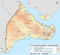
Fix:Byzantine Constantinople-en.png

Page contents not supported in other languages.
De Vicipedia

Fix orijinal(3,200 × 2,888 pixeles, grandia de fix: 2.35 MB, tipo MIME: image/png)

Esta fix veni de Wikimedia Commons e es cisa usada par otra projetas. La descrive en sua paje de descrive de fix ala es mostrada a su.

Vicipedia

 This is a featured picture on the English language Wikipedia (Featured pictures) and is considered one of the finest images. See its nomination here.

If you think this file should be featured on Wikimedia Commons as well, feel free to nominate it.
If you have an image of similar quality that can be published under a suitable copyright license, be sure to upload it, tag it, and nominate it.

Resoma

Descrive
English: Topographical map of Constantinople during the Byzantine period.
Български: Топографска карта на Константинопол (Цариград) през византийския период. Източник: R. Janin, Constantinople Byzantine. Developpement urbain et repertoire topographique. Пътната мрежа и някои други детайли се основават на Dumbarton Oaks Papers 54 и други публикувани източници.
Deutsch: Topografische Karte Konstantinopels während des byzantinischen Zeitraums. Quelle: R. Janin, Constantinople Byzantine. Developpement urbain et repertoire topographique. Straßennetz und andere Einzelheiten basiert auf Dumbarton Oaks Papers 54. Kirchen, insb. nicht identifizierte und ausgegrabene Bauten sind aus dem The Byzantine Churches of Istanbul entnommen. Andere herausgegebenen Quellen wurden behilfsmäßig gebraucht.
Ελληνικά: Τοπογραφικός χάρτης Κωνσταντινουπόλεως κατά τη Βυζαντινή περίοδο. Βασική πηγή χάρτη: R. Janin, Constantinople Byzantine. Developpement urbain et repertoire topographique. Το οδικό δίκτυο και διάφορες άλλες λεπτομέρειες με βάση το Dumbarton Oaks Papers 54. Πληροφορίες για τις εκκλησίες, ιδιαίτερα τις μη ταυτοποιημένες, από την ιστοσελίδα The Byzantine Churches of Istanbul του Πανεπιστημίου της Νέας Υόρκης.
Although I've striven to make this map as complete and correct as possible, there may be some errors or omissions. Any corrections & suggestions are welcome.
Data
Fonte

Own work using:

Autor Cplakidas
Permete
(Reusante esta fix)
I, the copyright holder of this work, hereby publish it under the following licenses:
w:en:Creative Commons
atribui share alike
Esta fix es lisensada su la lisensa Attribution-Share Alike 3.0 Unported de Creative Commons.
Tu es libre:
  • per comparti – per copia, distribui e transmete la obra
  • per remisca – per ajusta la obra
Su la constrinjes seguente:
  • atribui – Tu debe atribui la obra en la modo spesifada par la autor o lisensor (ma no en cualce modo cual sujesta ce el aproba tu o tua usa de la obra).
  • share alike – Si tu altera, muta o developa plu esta obra, tu pote distribui la obra resultante sola su la mesma lisensa o un simil a esta.
GNU head Permete es donada per copia, distribui e/o altera esta documento su la restrinjes de la GNU Free Documentation License, Varia 1.2 o cualce varia plu tarda publicida par la Free Software Foundation, sin partes nonvariante, sin testo de covrente fronte e sin testo de covrente retro. Un copia de la lisensa es incluida en la parte nomida GNU Free Documentation License.
Tu pote eleje la lisensa cual tu prefere
Other versions

[edita]

Full maps

SVG:

PNG:

Numeric versions

Regions

Roads

Open this image as an overlay in Google Earth (Google Maps, Bing) (Help|Source)

Captions

Add a one-line explanation of what this file represents
Constantinople during the Byzantine period

Items portrayed in this file

depicts English

copyrighted English

inception English

28 otobre 2008

MIME type English

image/png

checksum English

b4b5347456038e42cfa57b6c9763eaefb8d38a55

determination method English: SHA-1 English

data size English

2,462,235 bait

height English

2,888 pixel

width English

3,200 pixel

Istoria de fix

Clica un data/ora per vide la fix en sua forma de alora.

Data/OraImajetaMesurasUsorComenta
aora17:42, 25 april 2010Imajeta per revisa de 17:42, 25 april 20103,200 × 2,888 (2.35 MB)MahahahaneapneapCompressed
12:56, 15 desembre 2009Imajeta per revisa de 12:56, 15 desembre 20093,200 × 2,888 (3.42 MB)Cplakidaslarger & more detailed version, various corrections, Galata included
23:08, 30 junio 2009Imajeta per revisa de 23:08, 30 junio 20092,134 × 2,000 (1.62 MB)FalcorianLossless compression with pngout.
22:47, 8 janero 2009Imajeta per revisa de 22:47, 8 janero 20092,134 × 2,000 (1.84 MB)Cplakidasmore info, minor tweaks & corrections
11:48, 28 otobre 2008Imajeta per revisa de 11:48, 28 otobre 20082,134 × 2,000 (1.76 MB)Cplakidas{{Information |Description={{en|1=Topographical map of Constantinople during the Byzantine period. Map source: R. Janin, ''Constantinople Byzantine. Developpement urbain et repertoire topographique''. Road network and some other d

La paje seguente lia a esta fix:

Usa global de fix

La otra vicis seguente usa esta fix:

Mostra plu usas global de esta fix.

Metadatos