
Fix:Bretagne region location map.svg

Grandia de esta previde PNG de esta fix SVG: 800 × 496 pixeles. Otra densias: 320 × 198 pixeles | 640 × 397 pixeles | 1,024 × 635 pixeles | 1,280 × 793 pixeles | 2,560 × 1,587 pixeles | 1,615 × 1,001 pixeles.
Fix orijinal (fix svg, densia: 1,615 × 1,001 pixeles, grandia: 477 KB)
Resoma
| Camera location | | View this and other nearby images on: OpenStreetMap |
|---|
| Descrive |
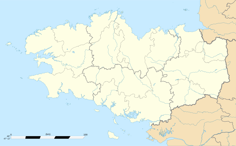
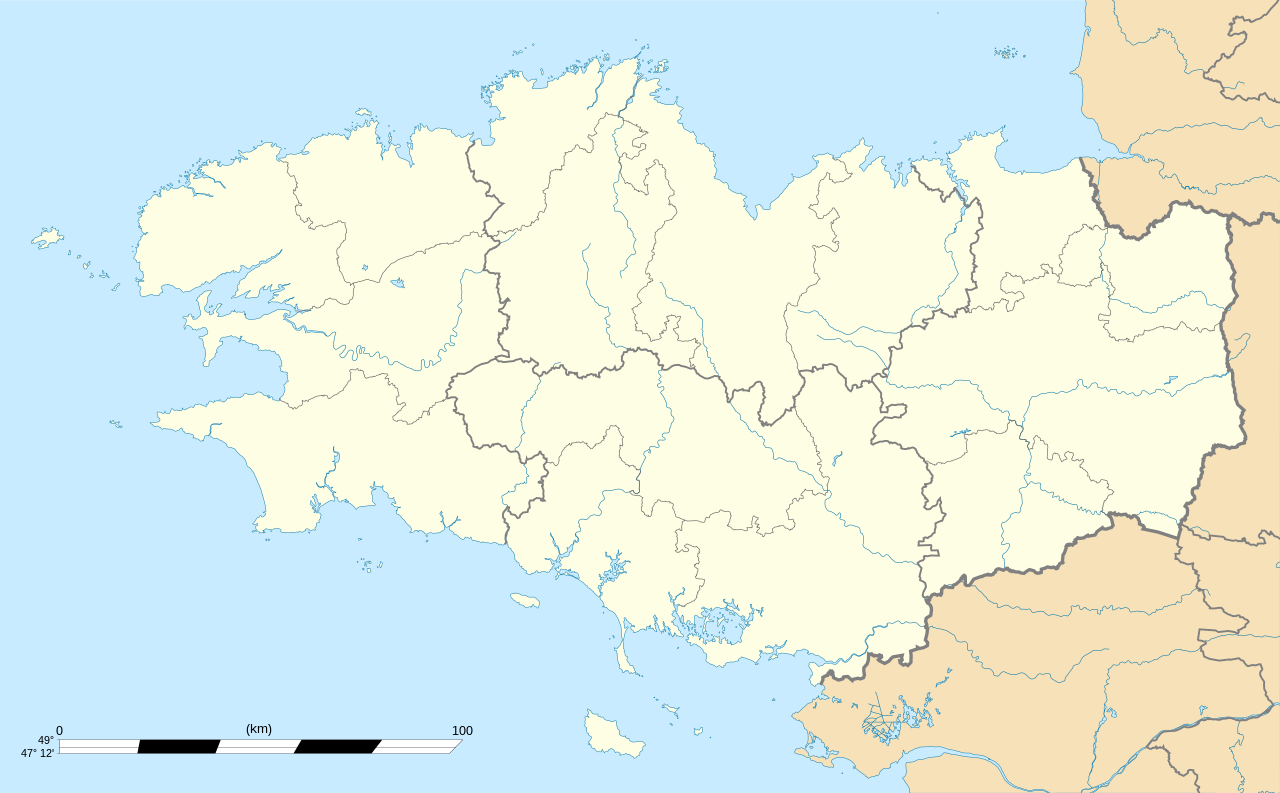
English: Blank administrative map of the region of Bretagne, France, for geo-location purpose, with distinct boundaries for regions, departments and arrondissements.
Français : Carte administrative vierge de la région Bretagne, France, destinée à la géolocalisation, avec limite distincte des régions, départements et arrondissements. Equirectangular projection, WGS84 datum
Geographic limits of the map:
|
||
| Data | |||
| Fonte |
Obra propre
|
||
| Autor | Eric Gaba (Sting - fr:Sting) | ||
| Permete (Reusante esta fix) |
|
||
| Other versions |
Derivative works of this file: Niver Brezhonegrien dre c'hant e pep bro Breizh, diouzh an diagnostik war stad ar brezhoneg graet e 2004.png
|

Lisensa
I, the copyright holder of this work, hereby publish it under the following licenses:
Esta fix es lisensada su la lisensa Attribution-Share Alike 3.0 Unported de Creative Commons.
- Tu es libre:
- per comparti – per copia, distribui e transmete la obra
- per remisca – per ajusta la obra
- Su la constrinjes seguente:
- atribui – Tu debe atribui la obra en la modo spesifada par la autor o lisensor (ma no en cualce modo cual sujesta ce el aproba tu o tua usa de la obra).
- share alike – Si tu altera, muta o developa plu esta obra, tu pote distribui la obra resultante sola su la mesma lisensa o un simil a esta.

|
Permete es donada per copia, distribui e/o altera esta documento su la restrinjes de la GNU Free Documentation License, Varia 1.2 o cualce varia plu tarda publicida par la Free Software Foundation, sin partes nonvariante, sin testo de covrente fronte e sin testo de covrente retro. Un copia de la lisensa es incluida en la parte nomida GNU Free Documentation License. |
Tu pote eleje la lisensa cual tu prefere
Istoria de fix
Clica un data/ora per vide la fix en sua forma de alora.
| Data/Ora | Imajeta | Mesuras | Usor | Comenta | |
|---|---|---|---|---|---|
| aora | 01:10, 7 agosto 2008 | | 1,615 × 1,001 (477 KB) | Sting | == Summary == {{Location|48|06|00|N|03|04|30|W|scale:2000000}} <br/> {{Information |Description={{en|Blank map of the region of Bretagne, France, for geo-location purpose.}} {{fr|Carte vierge de la région Bretagne, Franc |
Usas de fix
No pajes lia a esta fix.
Usa global de fix
La otra vicis seguente usa esta fix:
- Usa en als.wikipedia.org
- Usa en ar.wikipedia.org
- Usa en ast.wikipedia.org
- Usa en atj.wikipedia.org
- Usa en azb.wikipedia.org
- Usa en bg.wikipedia.org
- Usa en bn.wikipedia.org
- Usa en br.wikipedia.org
- Usa en ca.wikipedia.org
- Usuari:PereBot/cobertura/França Bretanya/ranking
- Usuari:PereBot/cobertura/França Bretanya/br
- Usuari:PereBot/cobertura/França Bretanya/ca
- Usuari:PereBot/cobertura/França Bretanya/cy
- Usuari:PereBot/cobertura/França Bretanya/de
- Usuari:PereBot/cobertura/França Bretanya/en
- Usuari:PereBot/cobertura/França Bretanya/es
- Usuari:PereBot/cobertura/França Bretanya/eu
- Usuari:PereBot/cobertura/França Bretanya/fr
- Usuari:PereBot/cobertura/França Bretanya/ga
- Usuari:PereBot/cobertura/França Bretanya/gl
- Usuari:PereBot/cobertura/França Bretanya/it
- Usuari:PereBot/cobertura/França Bretanya/nl
- Usuari:PereBot/cobertura/França Bretanya/pl
- Usuari:PereBot/cobertura/França Bretanya/sk
- Mòdul:Location map/data/França Bretanya
- Mòdul:Location map/data/França Bretanya/ús
- Mòdul:Location map/data/Bretanya
- Usa en ceb.wikipedia.org
- Usa en cs.wikipedia.org
- Usa en cy.wikipedia.org
- Usa en de.wikipedia.org
- Benutzer:Wahrerwattwurm/Trainingsgelände
- Wikipedia Diskussion:WikiProjekt Französische Gemeinden/Archiv/2008
- Wikipedia:Kartenwerkstatt/Positionskarten/Europa
- Vorlage:Positionskarte Frankreich Bretagne
- Vorlage Diskussion:Infobox Gemeinde in Frankreich/Archiv/2008
- Wikipedia Diskussion:WikiProjekt Georeferenzierung/Archiv/2010-I
Mostra plu usas global de esta fix.