
Fix:Basse Mesopotamie DA.PNG
No densia plu alta es disponable.
Basse_Mesopotamie_DA.PNG (440 × 393 pixeles, grandia de fix: 158 KB, tipo MIME: image/png)
| Descrive |
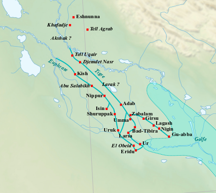
English: Map of the main cities of Lower Mesopotamia during the Early Dynastic period, with the approximate course of the rivers and the ancient shoreline of the Gulf. Français : Carte des principales villes de la Basse Mésopotamie durant la période des Dynasties Archaïques, avec le tracé approximatif des fleuves et l'ancien trait de côte du Golfe. |
| Data | (UTC) |
| Fonte | |
| Autor |
|
| This is a retouched picture, which means that it has been digitally altered from its original version. Modifications: Ajout du tracé approximatif des fleuves et du trait de côté du Golfe, et de villes.. The original can be viewed here: Near East topographic map-blank.svg:
|
I, the copyright holder of this work, hereby publish it under the following licenses:
This file is licensed under the Creative Commons Attribution-Share Alike 3.0 Unported, 2.5 Generic, 2.0 Generic and 1.0 Generic license.
- Tu es libre:
- per comparti – per copia, distribui e transmete la obra
- per remisca – per ajusta la obra
- Su la constrinjes seguente:
- atribui – Tu debe atribui la obra en la modo spesifada par la autor o lisensor (ma no en cualce modo cual sujesta ce el aproba tu o tua usa de la obra).
- share alike – Si tu altera, muta o developa plu esta obra, tu pote distribui la obra resultante sola su la mesma lisensa o un simil a esta.

|
Permete es donada per copia, distribui e/o altera esta documento su la restrinjes de la GNU Free Documentation License, Varia 1.2 o cualce varia plu tarda publicida par la Free Software Foundation, sin partes nonvariante, sin testo de covrente fronte e sin testo de covrente retro. Un copia de la lisensa es incluida en la parte nomida GNU Free Documentation License. |
Tu pote eleje la lisensa cual tu prefere
Original upload log
This image is a derivative work of the following images:
- File:Near_East_topographic_map-blank.svg licensed with Cc-by-sa-3.0,2.5,2.0,1.0, GFDL
- 2009-08-18T18:31:37Z Sémhur 2425x1581 (2442670 Bytes) 3 - New try
- 2009-08-17T15:39:22Z Sémhur 2425x1581 (1815374 Bytes) 2 - With the background...
- 2009-08-17T15:37:36Z Sémhur 2425x1581 (2836 Bytes) {{Information |Description={{en|1=Blank physical map of the [[:en:Near East|Near East]]}} {{fr|1=Carte physique vierge du [[:fr:Proche-Orient|Proche-Orient]].}} |Source={{own}} |Author=[[User:Sémhur|Sémhur]] |Date=2008-08-1
Uploaded with derivativeFX
Istoria de fix
Clica un data/ora per vide la fix en sua forma de alora.
| Data/Ora | Imajeta | Mesuras | Usor | Comenta | |
|---|---|---|---|---|---|
| aora | 22:44, 17 febrero 2023 | | 440 × 393 (158 KB) | Zunkir | cote et cours d'eau |
| 18:20, 4 febrero 2018 |  | 440 × 393 (181 KB) | Zunkir | Tracé des cours d'eau, locations sites. | |
| 12:04, 28 setembre 2010 |  | 1,021 × 730 (817 KB) | Zunkir | {{Information |Description={{en|1=Map of the main cities of Lower Mesopotamia during the Early Dynastic period, with the approximate course of the rivers and the ancient shoreline of the Gulf.}} {{fr|1=Carte des principales villes de la Basse Mésopotamie |
Usas de fix
La paje seguente lia a esta fix:
Usa global de fix
La otra vicis seguente usa esta fix:
- Usa en af.wikipedia.org
- Usa en ar.wikipedia.org
- Usa en arz.wikipedia.org
- Usa en ast.wikipedia.org
- Usa en az.wikipedia.org
- Usa en ba.wikipedia.org
- Usa en be.wikipedia.org
- Usa en ca.wikipedia.org
- Usa en cs.wikipedia.org
- Usa en cy.wikipedia.org
- Usa en de.wikipedia.org
- Usa en diq.wikipedia.org
- Usa en en.wikipedia.org
- Usa en eo.wikipedia.org
- Usa en es.wikipedia.org
- Usa en eu.wikipedia.org
- Usa en fa.wikipedia.org
- Usa en fi.wikipedia.org
- Usa en fr.wikipedia.org
Mostra plu usas global de esta fix.