
Fix:Algeria map-FR.png
No densia plu alta es disponable.
Algeria_map-FR.png (280 × 301 pixeles, grandia de fix: 67 KB, tipo MIME: image/png)
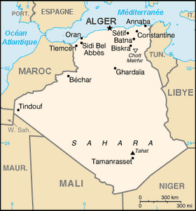
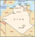
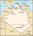
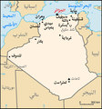
Map of Algeria, from the CIA World Factbook (with French text)
- Other versions:
[]
-
 blank PNG
 -
 blank SVG
 -
 English
 -
 français
 -
 français
 -
 lietuvių
 -
 עברית
עברית -
 čeština
 -
 svenska
 -
 español
 -
 العربية
 -
 日本語
日本語 -
 Afrikaans


This image is in the public domain because it contains materials that originally came from the United States Central Intelligence Agency's World Factbook.
|
 |
derivative works
Derivative works of this file: Algeria map-es.jpg
Istoria de fix
Clica un data/ora per vide la fix en sua forma de alora.
| Data/Ora | Imajeta | Mesuras | Usor | Comenta | |
|---|---|---|---|---|---|
| aora | 14:42, 25 maio 2005 | | 280 × 301 (67 KB) | Hégésippe Cormier | ---- Map of '''en:Algeria''', from the ''CIA World Factbook'' (with French text) :Same image, with English text, in Image:Algeria map-EN.png {{PD-USGov-CIA-WF}} |
Usas de fix
No pajes lia a esta fix.
Usa global de fix
La otra vicis seguente usa esta fix:
- Usa en an.wikipedia.org
- Usa en bg.wikipedia.org
- Usa en ca.wikipedia.org
- Llista de governants d'Algèria
- Frontera entre Algèria i el Marroc
- Plantilla:Fronteres d'Algèria
- Frontera entre Algèria i el Sàhara Occidental
- Frontera entre Algèria i Líbia
- Frontera entre Algèria i el Níger
- Frontera entre Algèria i Mali
- Frontera entre Algèria i Mauritània
- Frontera entre Algèria i Tunísia
- Batalla del banc de Skerki
- Usa en en.wikipedia.org
- Usa en eo.wikipedia.org
- Usa en fr.wikipedia.org
- Usa en fr.wikinews.org
- Usa en gl.wikipedia.org
- Usa en hr.wikipedia.org
- Usa en ht.wikipedia.org
- Usa en ku.wikipedia.org
- Usa en la.wikipedia.org
- Usa en ln.wikipedia.org
- Usa en pam.wikipedia.org
- Usa en rm.wikipedia.org
- Usa en roa-tara.wikipedia.org
- Usa en ro.wikipedia.org
- Usa en sg.wikipedia.org
- Usa en sg.wiktionary.org
- Usa en sk.wikipedia.org
- Usa en so.wikipedia.org
- Usa en vec.wikipedia.org
- Usa en vi.wikipedia.org
- Usa en wa.wikipedia.org
- Usa en wo.wikipedia.org
- Usa en zh.wikipedia.org