
Fix:600x600 GMT France topo-R1.jpg
No densia plu alta es disponable.
600x600_GMT_France_topo-R1.jpg (600 × 600 pixeles, grandia de fix: 343 KB, tipo MIME: image/jpeg)
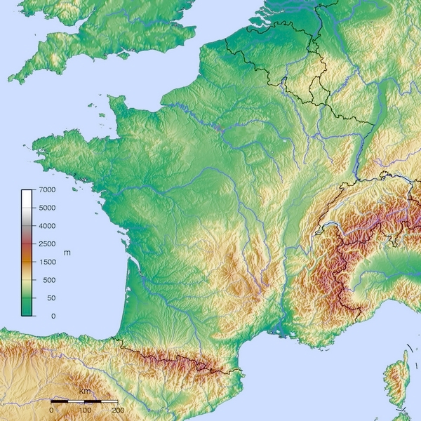
- Carte France GMT topographique R1
- Source:travail personnel
- licence:
The map has been created with the Generic Mapping Tools: https://www.generic-mapping-tools.org/ using one or more of these public-domain datasets for the relief:
|

|
Permete es donada per copia, distribui e/o altera esta documento su la restrinjes de la GNU Free Documentation License, Varia 1.2 o cualce varia plu tarda publicida par la Free Software Foundation, sin partes nonvariante, sin testo de covrente fronte e sin testo de covrente retro. Un copia de la lisensa es incluida en la parte nomida GNU Free Documentation License. |
- Auteur:Wikisoft* @@@-fr 10:22, 12 January 2013 (UTC)
-
- Projection Equirectangulaire
- top:52.30°
- bottom:41.00°
- left:-6.00°
- right:10.00°
Istoria de fix
Clica un data/ora per vide la fix en sua forma de alora.
| Data/Ora | Imajeta | Mesuras | Usor | Comenta | |
|---|---|---|---|---|---|
| aora | 10:22, 12 janero 2013 | | 600 × 600 (343 KB) | Wikisoft* | *Carte France GMT topographique R1 *Source:travail personnel *licence:{{GFDL-GMT}} *Auteur:~~~~ *Category:France *{{Atelier graphique carte}} *Projection Equirectangulaire *top:52.15 *bottom:41.00 *left:-6.00 *right:10.05 |
Usas de fix
La paje seguente lia a esta fix:
Usa global de fix
La otra vicis seguente usa esta fix:
- Usa en az.wikipedia.org
- Usa en bg.wikipedia.org
- Usa en bxr.wikipedia.org
- Usa en de.wikipedia.org
- Usa en el.wikipedia.org
- Usa en en.wikipedia.org
- Usa en eu.wikipedia.org
- Usa en fr.wikipedia.org
- Usa en hi.wikipedia.org
- Usa en hy.wikipedia.org
- Usa en id.wikipedia.org
- Usa en ja.wikipedia.org
- Usa en ko.wikipedia.org
- Usa en nds.wikipedia.org
- Usa en pt.wikipedia.org
- Usa en rm.wikipedia.org
- Usa en ru.wikipedia.org
- Usa en sl.wikipedia.org
- Usa en uk.wikipedia.org
- Usa en uz.wikipedia.org
- Usa en zh.wikipedia.org