
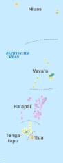
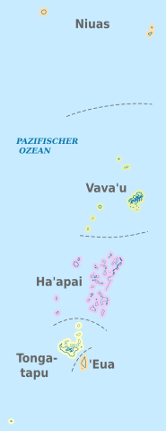
Fix:Tonga, administrative divisions - de - colored.svg

Grandia de esta previde PNG de esta fix SVG: 231 × 598 pixeles. Otra densias: 92 × 240 pixeles | 185 × 480 pixeles | 296 × 768 pixeles | 395 × 1,024 pixeles | 791 × 2,048 pixeles | 677 × 1,753 pixeles.
Fix orijinal (fix svg, densia: 677 × 1,753 pixeles, grandia: 219 KB)
Resoma


.svg)


_(Paris_zoom).svg)
.svg)
,_administrative_divisions_-_de_-_colored_(multizoom).svg)
_-_colored.svg)
.svg)
,_administrative_divisions_-_Nmbrs_(multizoom).svg)
,_administrative_divisions_-_de_-_colored.svg)
_-_de_-_colored.svg)

.svg)

.svg)
Lisensa
I, the copyright holder of this work, hereby publish it under the following licenses:
Esta fix es lisensada su la lisensa Attribution-Share Alike 3.0 Unported de Creative Commons.
- Tu es libre:
- per comparti – per copia, distribui e transmete la obra
- per remisca – per ajusta la obra
- Su la constrinjes seguente:
- atribui – Tu debe atribui la obra en la modo spesifada par la autor o lisensor (ma no en cualce modo cual sujesta ce el aproba tu o tua usa de la obra).
- share alike – Si tu altera, muta o developa plu esta obra, tu pote distribui la obra resultante sola su la mesma lisensa o un simil a esta.

|
Permete es donada per copia, distribui e/o altera esta documento su la restrinjes de la GNU Free Documentation License, Varia 1.2 o cualce varia plu tarda publicida par la Free Software Foundation, sin partes nonvariante, sin testo de covrente fronte e sin testo de covrente retro. Un copia de la lisensa es incluida en la parte nomida GNU Free Documentation License. |
Tu pote eleje la lisensa cual tu prefere

|
I'd greatly appreciate, that you attribute this media file to Wikimedia Commons, if used outside Wikipedia or Commons. For use in publications such as books, newspapers, blogs, websites, please insert here the following line:
|
Istoria de fix
Clica un data/ora per vide la fix en sua forma de alora.
| Data/Ora | Imajeta | Mesuras | Usor | Comenta | |
|---|---|---|---|---|---|
| aora | 15:52, 6 novembre 2012 | 677 × 1,753 (219 KB) | TUBS | == {{int:filedesc}} == {{Information |Description={{de|Karte der politischen Gliederung von XY (siehe Dateiname)}} {{en|Map of administrative divisions of XY (see filename)}} |Source={{own}}{{Adobe Illustrator}}{{Commonist}}{{AttribSVG|Haapai_in_Tonga... |
Usas de fix
La paje seguente lia a esta fix:
Usa global de fix
La otra vicis seguente usa esta fix:
- Usa en ca.wikipedia.org
- Usa en de.wikipedia.org
- Usa en de.wikivoyage.org
- Usa en en.wikipedia.org
- Usa en frr.wikipedia.org
- Usa en id.wikipedia.org
- Usa en is.wikipedia.org
- Usa en ja.wikipedia.org
- Usa en ko.wikipedia.org
- Usa en mt.wikipedia.org
- Usa en no.wikipedia.org
- Usa en pt.wikipedia.org
- Usa en sco.wikipedia.org
- Usa en uk.wikipedia.org
- Usa en zh.wikipedia.org