
Fix:Kingdom of France (1789).svg

Grandia de esta previde PNG de esta fix SVG: 450 × 456 pixeles. Otra densias: 237 × 240 pixeles | 474 × 480 pixeles | 758 × 768 pixeles | 1,011 × 1,024 pixeles | 2,021 × 2,048 pixeles.
Fix orijinal (fix svg, densia: 450 × 456 pixeles, grandia: 911 KB)
Resoma


.svg)
.svg)
.svg)
.svg)
.svg)


.svg)
.svg)
.svg)


.png)
.png)


.svg)


.svg)

.svg)


.svg)
.svg)
.svg)
.svg)


.svg)
.png)


.svg)


.svg)
.svg)


.svg)


.svg)


.svg)
.svg)
.svg)
.svg)
.svg)
.svg)
.svg)
.svg)
_cropped.svg)
.svg)
.svg)
.svg)
.svg)
.svg)
.svg)
.svg)
.svg)
.svg)
.svg)
.svg)
.svg)
.svg)
.svg)
.svg)
.svg)
.svg)
.svg)
.svg)
.svg)
.svg)
.svg)
.svg)
.svg)
.svg)
.svg)
.svg)
.svg)
.svg)
.svg)
.svg)
.svg)
.svg)
.svg)
.svg)
.svg)
.svg)
.svg)
.svg)
.svg)
.svg)
.svg)
.svg)
.svg)
.svg)
Istoria de fix
Clica un data/ora per vide la fix en sua forma de alora.
| Data/Ora | Imajeta | Mesuras | Usor | Comenta | |
|---|---|---|---|---|---|
| aora | 08:12, 17 otobre 2021 | | 450 × 456 (911 KB) | Fenn-O-maniC | Fixed the Russo-Swedish border to match the Treaty of Åbo of 1743 |
| 06:36, 29 desembre 2017 |  | 450 × 456 (914 KB) | TRAJAN 117 | Update | |
| 01:55, 25 desembre 2017 |  | 450 × 456 (832 KB) | TRAJAN 117 | +++ | |
| 02:14, 27 agosto 2013 |  | 450 × 456 (802 KB) | TRAJAN 117 | +++ | |
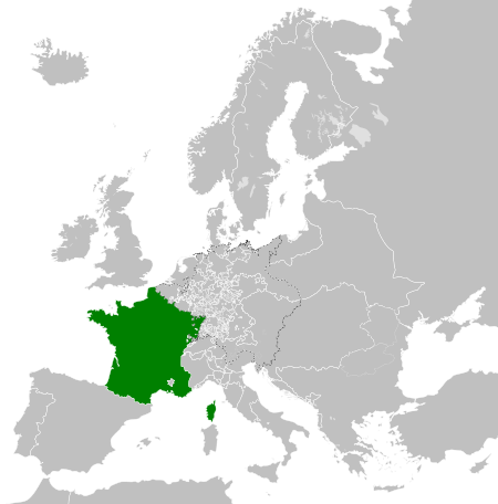
| 21:52, 7 maio 2013 |  | 450 × 456 (839 KB) | TRAJAN 117 | {{Information |Description ={{en|1=The Kingdom of France in 1789.}} |Source ={{own}} {{AttribSVG|Europe 1789.svg|Alphathon}} |Author =TRAJAN 117 {{created with Inkscape}} |Date =2013-05-07 |Permission ... |
Usas de fix
La paje seguente lia a esta fix:
Usa global de fix
La otra vicis seguente usa esta fix:
- Usa en ar.wikipedia.org
- Usa en arz.wikipedia.org
- Usa en ast.wikipedia.org
- Usa en az.wikipedia.org
- Usa en be.wikipedia.org
- Usa en bg.wikipedia.org
- Usa en cs.wikipedia.org
- Usa en da.wikipedia.org
- Usa en de.wikipedia.org
- Usa en el.wikipedia.org
- Usa en en.wikipedia.org
- Usa en es.wikipedia.org
- Usa en fa.wikipedia.org
- Usa en fi.wikipedia.org
- Usa en fr.wikipedia.org
- Usa en ga.wikipedia.org
- Usa en gl.wikipedia.org
- Usa en he.wikipedia.org
- Usa en hr.wikipedia.org
- Usa en hu.wikipedia.org
- Usa en id.wikipedia.org
- Usa en incubator.wikimedia.org
- Usa en is.wikipedia.org
- Usa en it.wikipedia.org
- Usa en ja.wikipedia.org
- Usa en ka.wikipedia.org
- Usa en ko.wikipedia.org
- Usa en lmo.wikipedia.org
- Usa en lt.wikipedia.org
- Usa en lv.wikipedia.org
- Usa en ms.wikipedia.org
- Usa en no.wikipedia.org
- Usa en nrm.wikipedia.org
Mostra plu usas global de esta fix.
.svg)
.svg)